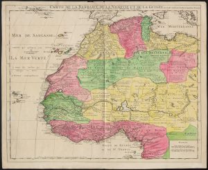
The Thomas J. Bassett Maps of Africa Collection is comprised of approximately 550 historical maps of Africa spanning from the mid-1500s to the early 1900s and offering a remarkable window into how the African continent was represented, imagined, and interpreted by European cartographers over the course of more than three centuries.
This collection stands out for its depth and focus, especially in relation to West Africa. It includes many rare and finely detailed maps produced during the nineteenth century, a period marked by increasing European exploration and colonization. These maps trace changing knowledge of African geography and reflect the ambitions and anxieties of colonial powers. At the same time, they bear traces—sometimes visible, often overlooked—of African influence. Local names, routes, and information gathered from African guides and informants made their way into these printed maps, offering evidence of African contributions to what were long assumed to be purely European productions.
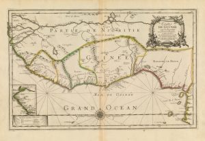
The Bassett Map Collection features the work of influential mapmakers such as Abraham Ortelius, Giacomo Gastaldi, Guillaume Delisle, and John Arrowsmith. The maps were published in major European centers including Paris, London, Venice, and Leipzig and appear in a variety of languages including Latin, French, English, German, and Italian. Many are richly illustrated and hand-colored, reflecting the artistry as well as the technical ambition of the cartographers.
More than a visual archive, the Bassett Map Collection serves as a research and teaching resource for understanding the complex intersections of geography, politics, empire, and indigenous knowledge. The collection reflects Professor Bassett’s lifelong commitment to the study of African landscapes and histories and his deep interest in how maps have shaped—and been shaped by—the worldviews of those who made and used them.
Materials in the Bassett Map Collection can be identified in the Library’s catalog by searching Thomas J. Bassett Maps of Africa Collection. These items are available for use in the Map Library; they may not be borrowed.
This collection is still under development. Additional pieces continue to be added.
Images of titles in the Basset Map Collection, and additional related materials from the Library’s collections, can be viewed through the Maps of Africa to 1900 digital collection. Images files may be freely downloaded through the digital collection.