James A. Bier was the Staff Cartographer in the University of Illinois Urbana-Champaign Geography Department from 1957 to 1989. After completing a degree in geology at Western Reserve University (now Case Western Reserve) and serving in the United States Army, where he was sent to “cartography school” and then to Japan for an impactful ten months, Mr. Bier arrived in Urbana to begin a Master’s degree in geography specializing in cartography. He came to the University expecting to learn more about cartography but ended up being the teaching assistant for the cartography classes. 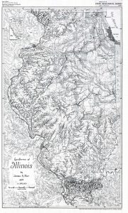
His work on the Illinois atlas led to his being “loaned” to the University of Hawaii in 1971-1972 to be the cartographer for their Atlas of Hawaii (1973). Returning to Urbana in 1972, Mr. Bier taught cartography classes in the Department of Geography, embarked on a decades-long specialized project of creating maps of Hawaii (published by the University of Hawaii Press), and produced more than 3,000 maps during his 30 years at the University of Illinois Urbana-Champaign and a very active 30 years of retirement.
The James A. Bier Map Collection and Archives contains more than 1,300 titles published during the 20th and early 21st centuries by a wide variety of governmental and corporate publishers; most of the materials were produced during the latter half of the 20th century. 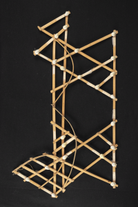
Supplementing the collection of published maps is an extensive collection of Mr. Bier’s manuscript maps which illustrate the process of hand compilation and drawing that was predominant in the 20th century before computer cartography applications were created. These manuscript materials are hand-drawn in ink or pencil, mostly on coated plastic or specialized drawing paper. Some pieces are hand-lettered while others have printed labels that have been attached with wax. Multiple flaps, or layers, each depicting different elements, are needed for some of the titles. The collection includes manuscripts for some of Mr. Bier’s Hawaii maps, some with hand-written corrections for new editions; Black Hills; New York landforms; and landform maps of Latin America and the Soviet Union which were never published. Additionally, the Map Library has a collection of Mr. Bier’s drawing tools, his label waxing machine, and correspondence relating to his work.
Published materials in the collection can be identified in the Library’s catalog by searching James A. Bier Map Collection. Many of these items may be borrowed.
Please contact the Map Library regarding the manuscript/archival portion of the collection. These items are still being processed and will be available for use only in the Map Library.