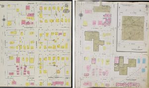
The Map Library holds a collection of 30,000 fire insurance maps produced between the 1880s and 1930s and covering approximately 550 cities in Illinois. The maps duplicate part of the fire insurance map collection held by the Library of Congress Geography and Map Division. Sanborn maps were created to assist insurance underwriters in determining fire insurance rates for individual buildings by examining the buildings’ construction methods, heat and lighting sources, use, and those same attributes in nearby buildings. Their purpose was to determine how likely it was that a building might catch fire. Sanborn maps are especially useful in providing a record of urban development from the 1880s through the 1950s. Family historians also find them useful for confirming the existence of family homes and businesses. The Sanborn Map Company was founded in 1867 by a surveyor named D. A. Sanborn. The company is of particular importance because by 1915 the company had monopolized the production of insurance maps in the United States. From 1915 through the 1960s, nearly every insurance map in the United States was made by Sanborn.
Sanborn maps tend to be at a large scale (the earliest are at 1:600), and sets include a tabular street and notable buildings index and a simplified map of the community with numbered rectangles overprinted to represent how individual sheets provide coverage. Commercial and industrial areas are usually fully represented, but residential areas are often incomplete. It is rare for an entire city to be mapped.
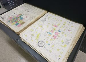
Most of the Map Library’s Sanborn fire insurance maps are loose, unbound sheets and can be retrieved by unit staff Monday through Friday between 9:00am and 4:30pm upon patron request. Distant users are encouraged to call or e-mail the Map Library to verify holdings. Map Library staff can assist in determining which sheets in the collection cover specific sites if users are able to provide site addresses, cross streets, or descriptions of the site, a specific building, nearby landmarks, or other location information.
Sanborn fire insurance maps are for in-library use only and will not be permitted to be taken from the Map Library for any reason. The Map Library is scanning its Sanborn holdings and making them available through the UIUC Library’s Digital Library as soon as the maps move into the public domain.
Map Library staff can assist in finding information about other libraries that have Sanborn map coverage of cities not included in the UIUC Sanborn collection.