The John A. Jakle Slide Collection consists of over 200,000 slides taken by Geography and Landscape Architecture Professor Emeritus John A. Jakle. The images are unique primary source materials held by no other library or collection and would be of interest to scholars in areas such as history, urban and regional planning, landscape architecture, geography, transportation, tourism/recreation, and agriculture.

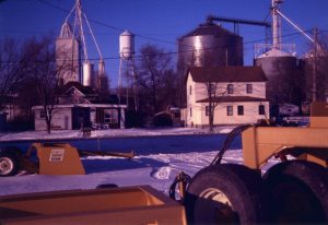
Along with documenting automobile-based travel or tourist experiences, Professor Jakle’s images focus on landscape change, urbanization, and rural farming communities. Change over time is especially well documented in the collection for areas in Chicago and Detroit as well as smaller towns including Bloomington, Champaign-Urbana, Terra Haute, and Kalamazoo as Professor Jakle returned to locations repeatedly through the years. He captured images of declining main streets, disappearing fences, and changes in farming scale from small, family farms to large-scale operations. Professor Jakle believes that a third of the landscapes and built environments he photographed no longer exist.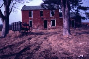
The collection is indexed and described through a series of three-ring binders which serve to point users to specific slide cases. Please speak with Map Library staff for assistance with the index binders and access to the collection.
Books written by Professor Jakle can be found in the University Library’s catalog by searching John A. Jakle as an author.

The Map Library has also received from Professor Jakle an extensive collection of road and city street maps primarily distributed freely by American and Canadian petroleum companies between the 1920s and the 1980s. This collection is not yet available for use.