|
<Primary Source Home
<Module 1 Home
Module 1: What are primary sources?
|
Maps are symbolic representations of a part of the earth’s surface. They can reveal how places – a college campus, a city, a street – changed over time. They often reflect changing political realities and understandings, as well as advancing degrees of knowledge about the spaces represented. Like all types of primary sources, maps are social documents: they are created in a particular social and cultural context, and they contain certain details, leave others out, and represent relative sizes and other features of geographic areas and social spaces with a lesser or greater degree of accuracy.
No map is entirely accurate, but in general, maps tend to be more accurate the smaller the area they represent. In fact, there are inherent problems in even trying to represent the round surface of the earth in two dimensions. Since this can’t be done, there are significant distortions in maps representing large areas of the earth’s surface.
p. 13/15
|
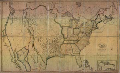
This map of the United States was made in 1813 by a Philadelphia mapmaker named John Melish. Do you see any differences between the way Illinois is shaped here and the way it is represented in maps today? What do you think might account for any differences?
This map was digitized as part of the Historical Maps Online digital collection.
University of Illinois Map and Geography Library. Call # G3700 1818
|